
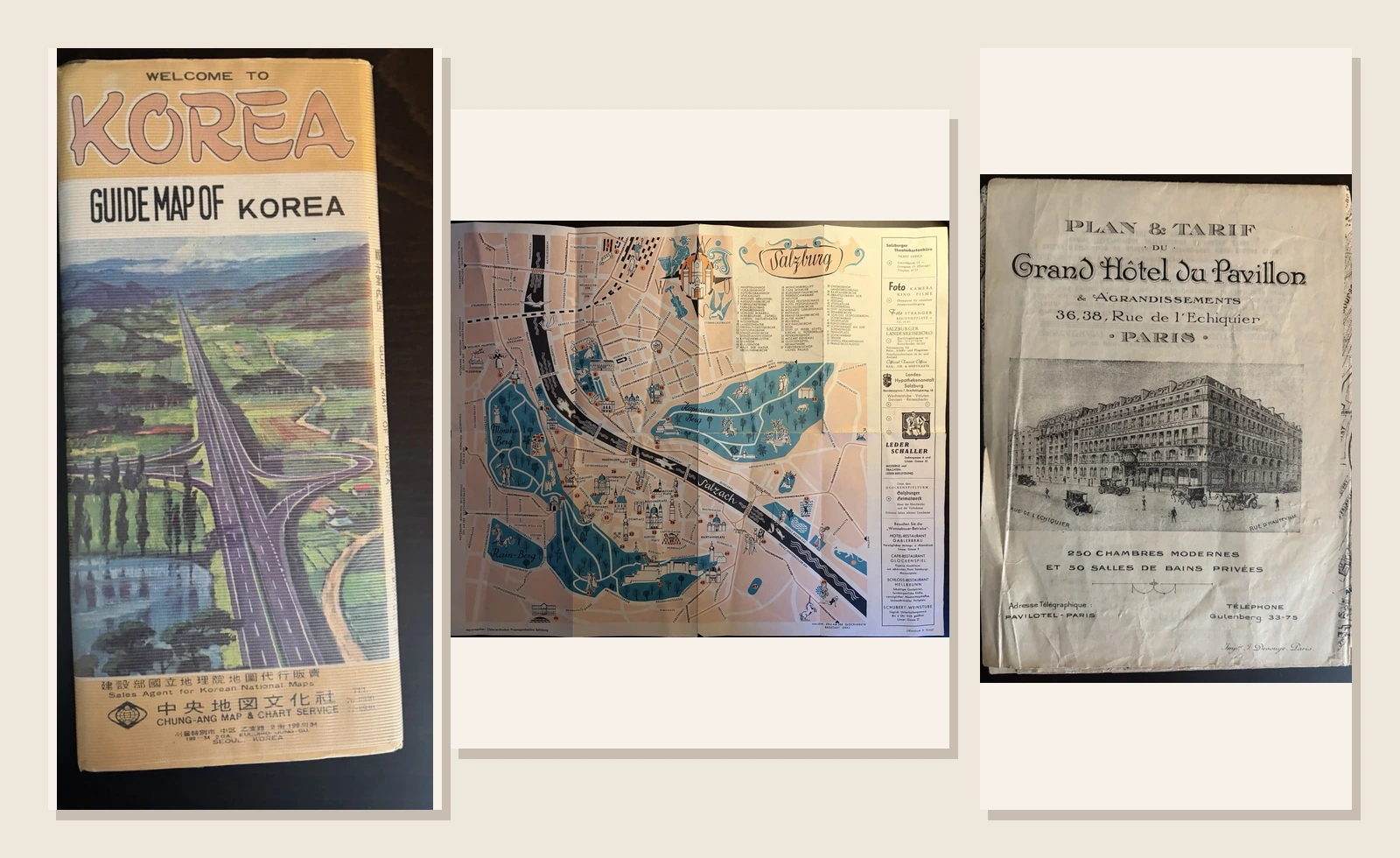
A visitor map anticipates the decisions likely to trouble a newcomer: which road to take, where to leave a station and how to find the hotel. Before the traveller arrives, the publisher has already selected the geography most likely to help.
Three sheets make that editing unusually clear. One presents the Republic of Korea at 1:500,000 in 1976. Another turns Salzburg into a salmon and turquoise picture, probably around 1950. The third was sent from a Paris hotel with a typed letter on 5 March 1921. They have no shared journey and should not be made to invent one. Their connection is functional: all three reduce uncertainty, but at the scale of a country, a city and a single building.
A country behind one cover
The folded Korean guide begins with speed. A motorway runs from the foreground towards low mountains, painted across a ridged plastic sleeve. “Welcome to Korea” and “Guide Map of Korea” are set above it in English. Below, Chung-Ang Map & Chart Service describes itself as sales agent for Korean National Maps. Even before the sheet is opened, the country has been introduced through modern movement.
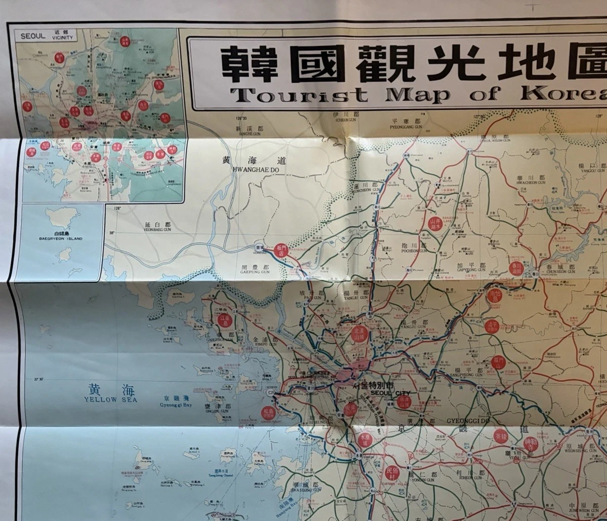
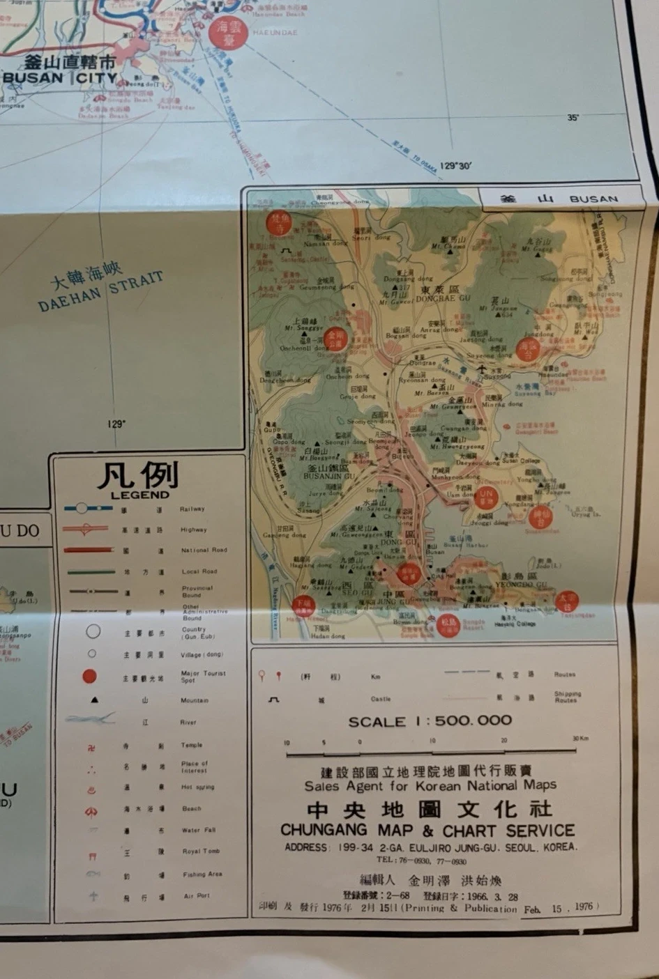
Inside, the motorway becomes one strand in a much denser network. Railways, highways, national and local roads are separated in the legend; provincial and administrative boundaries use their own marks. A blue coast gives the peninsula a clean edge, while red circles interrupt the quieter ground. The key identifies them as major tourist spots. They do not merely mark settlements. They make recommendations.

The sheet changes scale without asking the user to change maps. Seoul receives a vicinity plan at the upper left. Busan and Jeju appear lower down; islands and routes sit beside a compact English legend. The printing line gives 15 February 1976, one of the welcome occasions when the object provides its own firm date. The cover’s optimism and the map’s patient detail belong to the same proposition: arrival may be exciting, but onward travel requires a system.
Tickets, postcards and a drinks leaflet now accompany this copy. They enrich the group without proving that every piece began together. One ticket shows 1975; the green Jinro item and postcard views carry their own histories. I would describe them as associated travel ephemera, not as a sealed traveller’s archive. That small distinction preserves what can be seen without turning proximity into provenance.
Salzburg performs its geography
Salzburg answers uncertainty with theatre. The Salzach is a dark ribbon crossed by small figures; churches stand up from the street plan; walkers, riders, skiers and animals occupy the blue hills. The palette is limited, but the city never feels austere. Salmon blocks establish the streets, turquoise makes landscape memorable, and black linework keeps the whole composition legible.

Fifty-five references sit beneath the script title. Hauptbahnhof and the local bus station come first; Mozart’s birthplace, the cathedral, festival buildings, swimming baths and St Francis Castle follow. The list does not separate culture from logistics. A railway station and a monument are simply distinct replies to one visitor question: where is it?
The right-hand advertising strip pushes the idea further. A theatre ticket office, camera shop, travel bureau, bank, leather dealer and restaurants all buy space beside the official key. Their presence is not visual clutter left over after the map was finished. It records the commercial city into which the tourist was being received. Directions and desire occupy one sheet because the useful plan also had to circulate.

Turn the paper and the performance changes. The figures disappear, the scale expands and Salzburg becomes a hub among lakes, passes, roads and Alpine relief. Bad Ischl, Zell am See, the Grossglockner High Alpine Road and the peaks to the south make the city one point in a regional journey. The two faces divide the traveller’s attention neatly: first understand the streets; then consider leaving them.

The lower margin credits the Österreichisches Propagandabüro Salzburg as publisher and R. Kiesel with the offset printing. No year is visible. Similar guide material associated with the office straddles the wartime divide, and therefore the name alone cannot settle an issue date. The listing’s circa 1950 remains useful as a stylistic estimate, provided “around” does the honest work.
Paris measured from the lobby
The Grand Hôtel du Pavillon begins not with Paris but with itself. Its folded cover presents the corner façade at 36–38 rue de l’Échiquier, surrounded by early motor cars and horse-drawn vehicles. It announces 250 modern rooms, 50 private bathrooms, the telegraphic address Pavilotel-Paris and telephone number Gutenberg 33-75. The visitor has not yet seen a street plan, but already has a building to aim for.

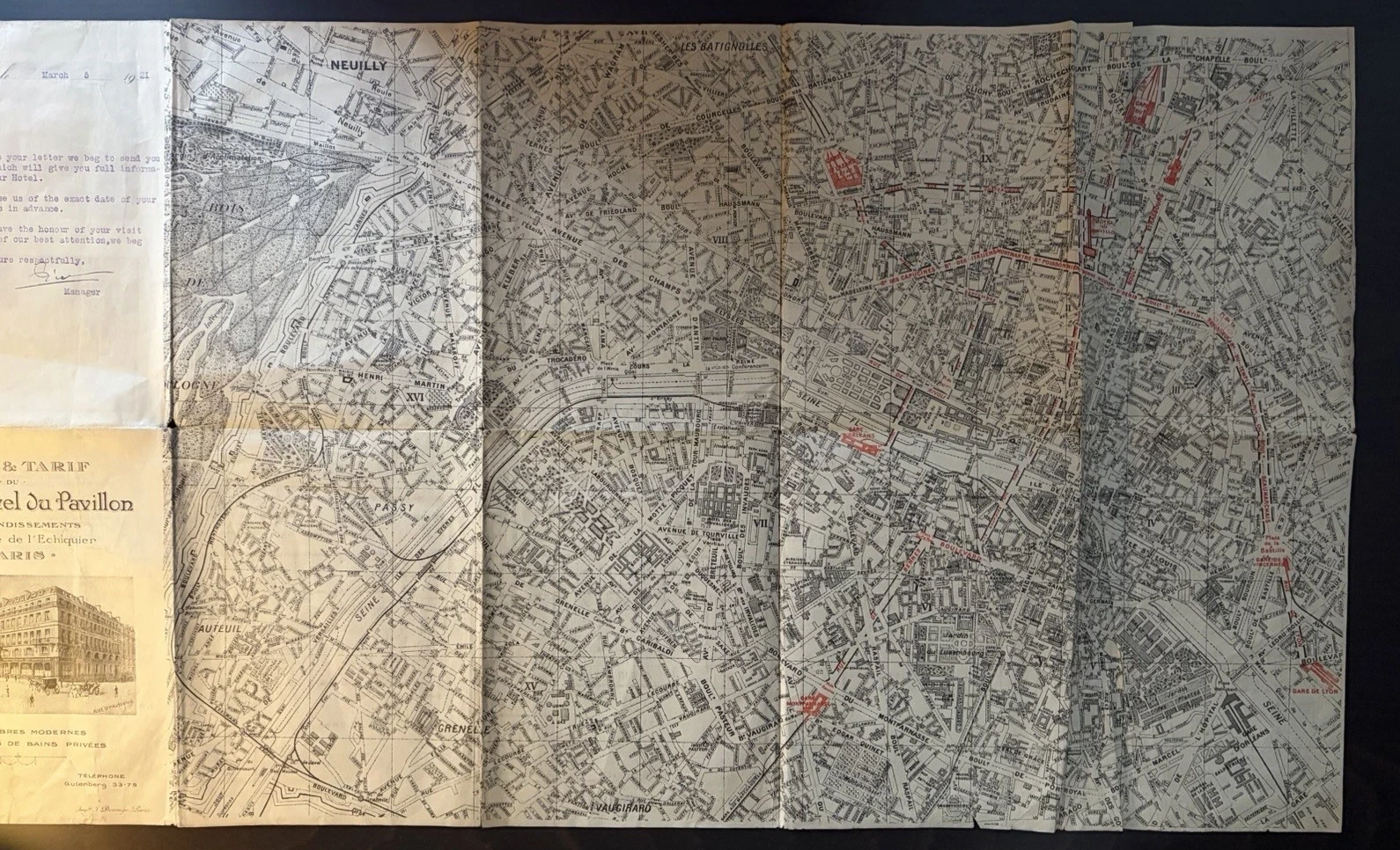
A street map on the reverse widens that centre. Railway termini, main boulevards and selected landmarks are picked out in red, giving an arriving guest a field of connections rather than an abstract municipal survey. Paris is edited from the hotel lobby outwards. The address panel remains attached at the edge, so the traveller’s point of return survives even when the city occupies the table.
The other face moves inward. Plans run from the ground floor and mezzanine to the fifth storey. Rooms are numbered around three courtyards; baths and service spaces are indexed below each diagram. A general tariff, meal prices, photographs of the restaurant, salons, smoking room and a bedroom complete the explanation. Even interpreters and guides for excursions receive a line. This is architecture converted into reassurance.

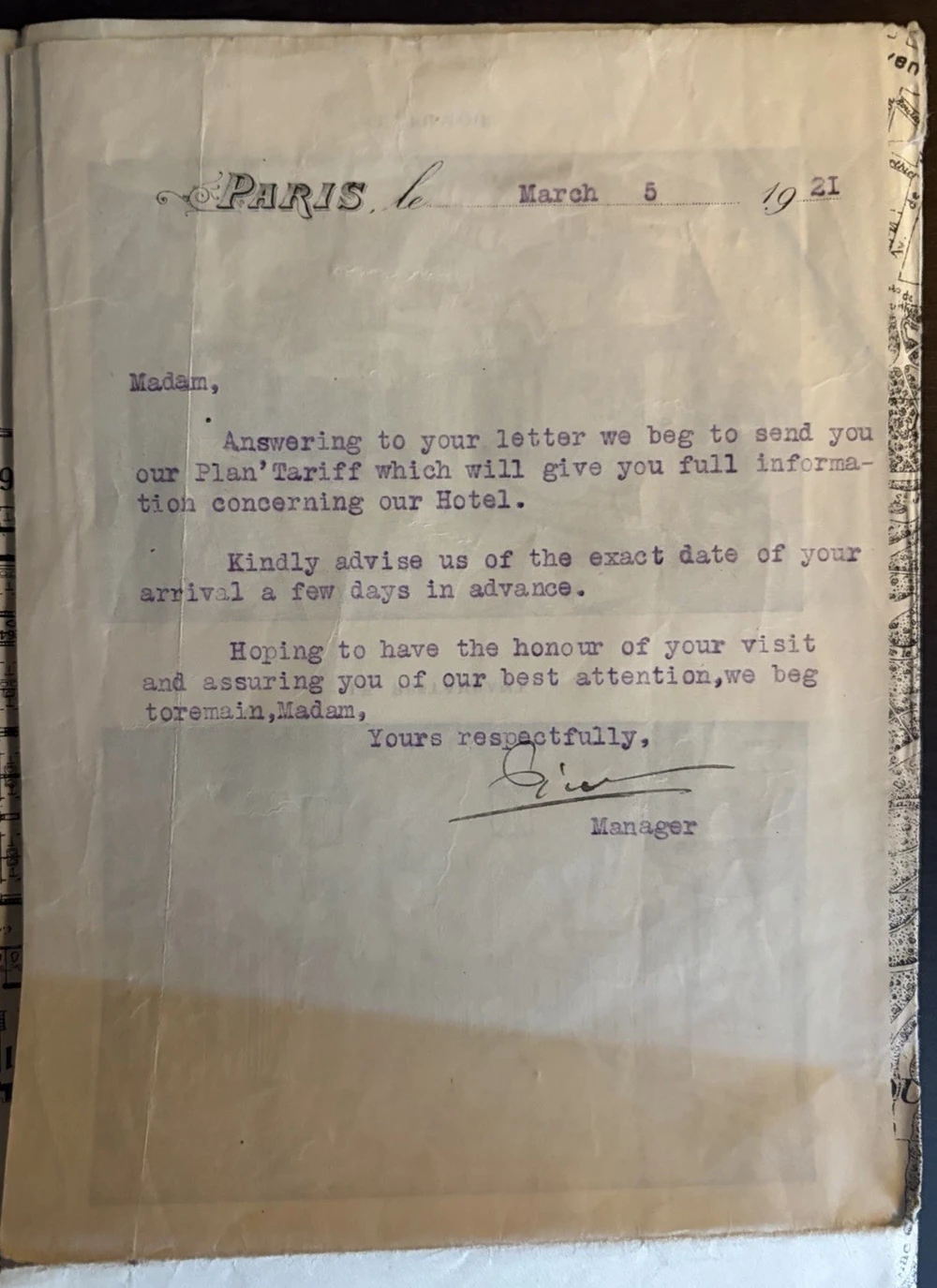
The accompanying letter supplies a precise moment. Addressed simply to “Madam” and typed in English on 5 March 1921, it sends the plan and tariff in response to an enquiry, then asks for the exact arrival date a few days in advance. That is the entire journey of the document in miniature: request, information, intended booking. The date belongs securely to the letter. I would not assume, without further evidence, that every printed section was first issued that day.
What the folds were asked to do
All three objects alternate between promise and instruction. Korea’s sleeve advertises a modern road before releasing a national network. Salzburg offers a picture city on one face and an Alpine region on the other. The Paris cover turns a hotel into a destination, then opens into prices, floors and streets. None would work as well if permanently flat.
The creases therefore belong to the design before they belong to condition. They let a broad field travel in a pocket or envelope, but every opening puts new stress on the same intersections. The Korean sheet shows persistent fold lines and cover wear; Salzburg has local weakness and small marks; the Paris piece carries edge losses, splits, annotations and an attached letter. These signs do not identify their owners. They do record repeated changes of scale, from compact object to temporary territory.
Three scales, three questions. On the Korean sheet, ask how to reach the next region. In Salzburg, ask which landmark will make the city recognisable. In the hotel plan, ask how to return to one room and one address. Then inspect what has been enlarged, numbered or coloured. Those choices reveal the traveller imagined by the publisher.
A tourist map does not wait passively for someone to become lost. It rehearses the difficulty and arranges an answer in advance. Red circles, playful figures and numbered bedrooms are three different kinds of hospitality. Their paper survives because each was made to accompany a body in motion—and because, for a few unfolding minutes, it could make an unfamiliar place feel prepared.
Sources and dating
The three pieces considered here are a 1976 Tourist Map of Korea issued by Chung-Ang Map & Chart Service, a pictorial Salzburg tourist plan listed as circa 1950, and a Grand Hôtel du Pavillon plan, tariff and letter. Dates, credits, scale, wording and condition observations come directly from the object photographs. The printed Korean publication line reads 15 February 1976; the Paris letter reads 5 March 1921; the Salzburg sheet supplies no visible year.
BnF’s account of Paris cartography is useful on the city plan as both technical abstraction and an image that encourages discovery. The Salzburg Festival’s historical report on Poldi Wojtek and the Festival’s visual culture supplies archival context for the Österreichisches Propagandabüro; it does not date this map. For another comparison of portable urban mapping, read Three Pocket Hong Kongs on Paper. The London Zoo plan shows how a visitor sheet can organise not only space but time.